| Directions
From I-87 exit 29, proceed west on the Blue Ridge
Road.
In about 5.3 miles, you will cross The Branch (a creek)
and just beyond this on the right, there is a parking
lot. There is a sign on the corner. The trailhead for Hoffman Notch Trail
is across the road.
|
| County: |
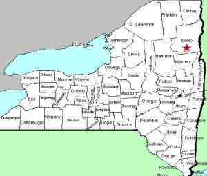
Essex |
| Town: |
North Hudson |
| USGS Map: |
Blue Ridge |
| Waterway: |
Hoffman Notch Brook |
| Latitude: |
N 43° 56' 18" |
| Longitude: |
W 73° 51' 07" |
| Drop: |
12' |
| Type: |
Slide |
| Region: |
West of North Hudson |
| Parking: |
Roadside shoulder |
| Trail type: |
Dirt |
| Length of hike: |
2.4 mi, one-way |
| Difficulty: |
Moderate |
| Accessibility: |
Public |
| Name: |
Common |
|
 For
several years, we have had a page on this website for Hoffman
Notch Falls. A contributor has recently informed us that
there are two waterfalls on tis stream. There may well be
more. It appears that bushwhacking will be in order to get
to those drops further upstream. He will be making a
return trip there in the future to research this. For
several years, we have had a page on this website for Hoffman
Notch Falls. A contributor has recently informed us that
there are two waterfalls on tis stream. There may well be
more. It appears that bushwhacking will be in order to get
to those drops further upstream. He will be making a
return trip there in the future to research this.
From the parking lot, carefully cross over Blue Ridge Road
and follow a path down to the trailhead. If you use
AllTrails it is the Hoffman Notch Trail. The first 1.3
miles of the trail are on private property and it is heavily
posted to stay on the trail. You will pass a 1930's era car
along the way as well as a few footbridge crossings and you
will pass through a beautiful hemlock grove.
At 1.4
miles you are now on Vanderwhacker Mountain Wild Forest
land, you will cross over Notch Brook and the trail will
turn left to go along the brook. It is a steady uphill climb
from here, not steep, just steady. You will pass a few small
cascades and an old tractor that was used to haul logs back
in the mid 1900s.
At 2.4 miles from the
parking lot you will reach Hoffman Notch Lower Falls on the
left side of the trail. You can see the falls from the
trial, but It requires a little off-trail effort to get down
to the brook for some good photos.
This waterfall is
12' tall. We were there during a low flow time period which
exposed some beautiful rock features.
After viewing
the falls, return to the trail and continue upstream for 0.6
miles to Hoffman Notch Upper Falls.
Hoffman Notch Brook flows into the Branch, which empties into
the Schroon River just southwest of the hamlet of North Hudson.
The Schroon flows through Schroon Lake and then continues its journey
to the Hudson River just outside of the village of Warrensburg.
The Hudson flows into the Atlantic ocean in New York City.
Our thanks to Gary Dilmore for the photos and information on
this location.
Last update: September 7, 2026
|