| Directions
In our description for
Stair Falls,
you were parked near the corner of Vineyard Road and
Middle Road. Drive east on Middle Road and take
the first left onto Creek Road/CR 2. You will see this
stretch on the left within a short distance.
|
| County: |
Essex |
| Town: |
Crown Point |
| USGS Map: |
Crown Point |
| Waterway: |
Putnam Creek |
| Latitude: |
N 43°
56' 28" |
| Longitude: |
W 73°
28' 19" |
| Drop: |
15' |
| Type: |
Multiple cascades |
| Region: |
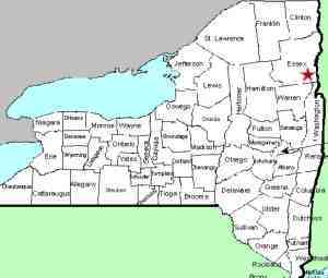
Off NY 22/9N north
of the hamlet of Ticonderoga |
| Parking: |
Roadside shoulder |
| Trail type: |
Dirt/rock/grass |
| Length of hike: |
<0.1 mile,
1 minute |
| Difficulty: |
Moderate |
| Accessibility: |
Public, much is
private |
| Name: |
Common |
|
As mentioned in the entry for Stair Falls, we used to list
this entire region as one entry. We recently decided that
since there are three distinct drops here, it warranted
separating them.
As you drive up CR 2, you will come to a stretch of Putnam Creek on your left.
Park on the roadside and explore. We do believe that this
area is private so please respect that.
Whereas Stair Falls and Stair Upper Falls are both single
drops, this is a series of drops. Because of that and
because it is part of what is considered Stair Falls, we have chosen the name Stair
Falls Cascades to catalog it. We aren't positive how much
elevation change there is in the stretch. The 15 feet we
have noted in the data side-bar is for the uppermost drop.
This is the tallest of the several "waterfalls" that make up
this section.
The first four photos in the array are views along this
stretch. The last two pics are of the uppermost drop,
which is the most significant one.
Putnam Creek is probably one of the smaller waterways containing
a waterfall that flows directly into the main outlets of northern
New York. The main falls is only about three miles from the
outlet to Lake Champlain.
Last update: September 21, 2026
|