| Directions
We have recently learned that this area is accessible.
We are working on specifics to the trailhead.
|
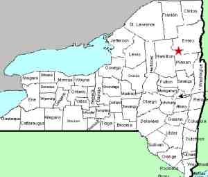
| County: |
Hamilton/Essex |
| Town: |
Minerva |
| USGS Map: |
Dutton Mt |
| Waterway: |
Hudson River |
| Latitude: |
N 43o 48' 50" |
| Longitude: |
W 74o 07' 40" |
| Drop: |
NA |
| Type: |
Rapids |
| Region: |
Essex/Hamilton County line |
| Parking: |
NA |
| Trail type: |
NA |
| Length of hike: |
NA |
| Difficulty: |
NA |
| Accessibility: |
Unknown |
| Name: |
Common |
|
According to Mike Chotkowski, who guides in that
area, osprey Nest can be reached via a bushwack in from NY 28 to
Carter Pond via Ross and Whortlberry Ponds. Then follow the outlet
to Carter Landing on the Hudson and you will be just below osprey
Nest Rapid.
Mike also tells us that it is interesting to note that Carter
Brook goes underground on its way to the Hudson for almost a quarter
mile. This route will also take you to oK Slip Falls.
It is the "official" trail in and is marked with orange
nylon tape tied to branches at this point. DEC is still discouraging
use until the trail is laid but he sees people in there every weekend.
This is a named stretch of rapids on the Hudson River, just upstream
from where the oK Slip Brook enters.
If anyone has pictures of this area, please
contact us.
The Hudson River empties into the Atlantic ocean in New York
City.
Last update: october 19, 2015
|


