| Directions
This waterfall is located between the Bryant Bridge
Road bridge over the Oswegatchie and the Harrisville Rod
& Gun Club. It is on private property and is only
accessible with owner permission or by canoe/kayak on
the river.
|
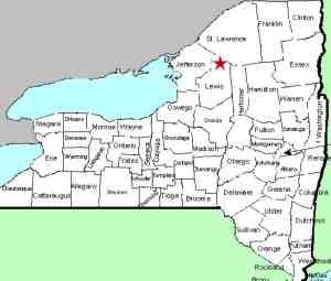
| County: |
Lewis |
| Town: |
Diana |
| USGS Map: |
Oswegatchie SW |
| Waterway: |
Oswegatchie River
Middle Branch |
| Latitude: |
N 44° 04'
34" |
| Longitude: |
W 75°
15' 52" |
| Drop: |
20' |
| Type: |
Ribbon cascade |
| Region: |
South of Harrisville |
| Parking: |
Roadside |
| Trail type: |
Water access |
| Length of hike: |
NA |
| Difficulty: |
NA |
| Accessibility: |
Private |
| Name: |
Common |
|
This is not indicated
on topographical maps but is well known in the whitewater community.
Our thanks to Marsha Davis Spiridigliozzi for the pictures of
this waterfall. Marsha has provided us with a number of photos
of falls in this area. She took some of these and others
were taken by the late Larry Cole. They were both staff
writers for the Watertown Daily Times at the time the shots were
taken.
If anyone else has any information or pictures on this area, please
contact us.
The Middle Branch enters the West Branch of the Oswegatchie River
about a mile and a half south of Harrisville. This flows into the main
branch just west of the hamlet of Talcville in the town of Edwards.
The Oswegatchie River flows into the St. Lawrence River in Ogdensburg,
New York.
Last update: September 26, 2017
|