| Directions
1.7 miles north of the intersection
of Routes 30 and 8 in Wells, there is a dirt road off
to the right. Actually there are two dirt roads
exiting at the same spot, each one somewhat paralleling
the highway in opposite directions. Take the right
fork. It is about 0.1 mile long.
|
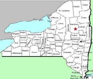
| County: |
Hamilton |
| Town: |
Wells |
| USGS Map: |
Harrisburg |
| Waterway: |
Sacandaga River |
| Latitude: |
N 43°
28' 02" |
| Longitude: |
W 74°
14' 47" |
| Drop: |
100' |
| Type: |
Cascade |
| Region: |
On
NY 30 between Speculator and Wells |
| Parking: |
Unpaved
lot |
| Trail
type: |
Dirt |
| Length
of hike: |
0.2
miles/5 minutes |
| Difficulty: |
Easy |
| Accessibility: |
Public |
| Name: |
Official |
|
 Auger Falls is located
on a stretch of NYS Routes 30 and 8 that run together from Speculator
to just north of Wells. At the end there is a trail leading
into the woods where you will almost immediately come to a registration
kiosk. There is a sign on it asking visitors to register so
that the NYS DEC can track use to justify maintenance expenditures
and for information in the event of an emergency. Your 0.2
mile walk from this point is on a trail that is fairly welled maintained,
complete with yellow trail markers, and easy to pass. Auger Falls is located
on a stretch of NYS Routes 30 and 8 that run together from Speculator
to just north of Wells. At the end there is a trail leading
into the woods where you will almost immediately come to a registration
kiosk. There is a sign on it asking visitors to register so
that the NYS DEC can track use to justify maintenance expenditures
and for information in the event of an emergency. Your 0.2
mile walk from this point is on a trail that is fairly welled maintained,
complete with yellow trail markers, and easy to pass.
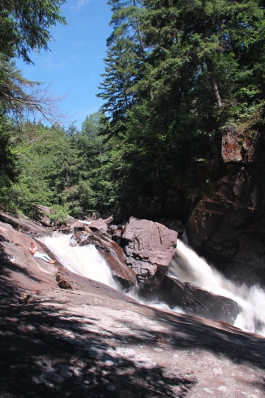
Auger Falls drops in several steps, the main one being a plunge
of 40'. The falls probably got its name from the action of
the water as it turns its way through the narrow gorge. Take
note of the fact that your vantage point is atop the mighty rocks
that rise above the gorge. There are some spots where you
could probably descend and get closer to the river level.
Either way, there are no fences or retaining devices. Although
you are only 1/4 mile off a major highway, this is an undeveloped,
wild area. As with any waterfall, use caution as you enjoy
this area.
The Sacandaga River flows through a number of lakes as it makes
its way to the Hudson River whose final destination is the Atlantic
Ocean.
Last update: August 26, 2017
|