| Directions
The Ausable Chasm area is located on NYS Route 9 between
Plattsburgh and Keeseville. It is a heavily commercialized
scenic attraction that you will have no trouble finding.
|
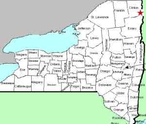
| County: |
Clinton/Essex |
| Town: |
Ausable/Chesterfield |
| USGS Map: |
Keeseville |
| Waterway: |
Ausable River |
| Latitude: |
N 44o 31' 25" |
| Longitude: |
W 73o 27' 37" |
| Type: |
Multiple |
| Drop: |
91' |
| Region: |
Northeast Essex County |
| Parking: |
Paved parking area |
| Trail type: |
Mixed |
| Length of hike: |
1 - 1.5 hours |
| Difficulty: |
Moderate |
| Accessibility: |
Business |
| Name: |
Some official, some common |
|
This attraction is actually on the Clinton/Essex County Line.
We have opted to list it on our county list in Essex County because
the visitors' center and the best views of Rainbow Falls are on
that side of the river.
On a side note, Ausable Chasm was formerly known as Birmingham
Falls and before that, Adgate Falls. Several sources state
these names. Although not much detail is given as to
when these names were used, it is known that the attraction at Ausable
Chasm was established in 1870, and sources have been found referring
to Birmingham Falls in 1851 and as early as 1792. Adgate Falls
predated these.
|
|
 The promotional flyers bill it as "the
oldest and largest natural attraction in the Adirondacks" and
it has been called the "Grand Canyon of the east".
It is a beautiful scenic area, well maintained and demonstrating
the effects of millions of years of erosion. Although the
area does offer a lot, to the waterfall lover, it may be a disappointment. The promotional flyers bill it as "the
oldest and largest natural attraction in the Adirondacks" and
it has been called the "Grand Canyon of the east".
It is a beautiful scenic area, well maintained and demonstrating
the effects of millions of years of erosion. Although the
area does offer a lot, to the waterfall lover, it may be a disappointment.
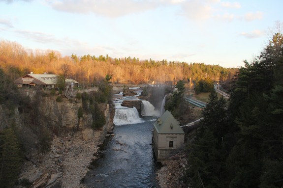
When you enter the welcome center, you will find the counter
where you pay for the options you wish to see. This is one
of very few locations that we know of in the Adirondacks where you
will pay to see the waterfalls, certainly the most costly.
There is also a large gift shop, a cafe and maps of the area. The
basic admission was $16.00 per adult in 2011. For that price
you get to hike any of three trails. We chose the Inner
Sanctum trail which took you along the sides of the gorge, closest
to the river level for these three trails. At the end of any
of the options, a shuttle bus returns you to the area above the
gift shop by Rainbow Falls for a closer view.
There is also a "Cave and Falls Hike" available.
In addition to the basic $16 charge, this is $10 more per person.
It is our understanding that this takes you down to the river level
and you do get to view six of the seven falls. Most waterfalls
aficionados enjoy hiking natural trails to view waterfalls.
It is an individual decision as to whether you want to pay $26 per
person for this privilege. We chose not to do this, not because
of the cost but because of the timing. This is a guided hike
and only available at select times of the day. We arrived
late morning just after the last morning tour had departed.
The next one was almost 2-1/2 hours later. Between the wait
and the fact that we had five other falls and about 150 miles to
drive on our agenda that afternoon, we opted out.
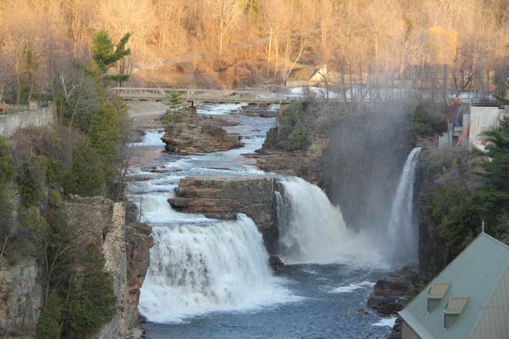
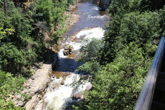
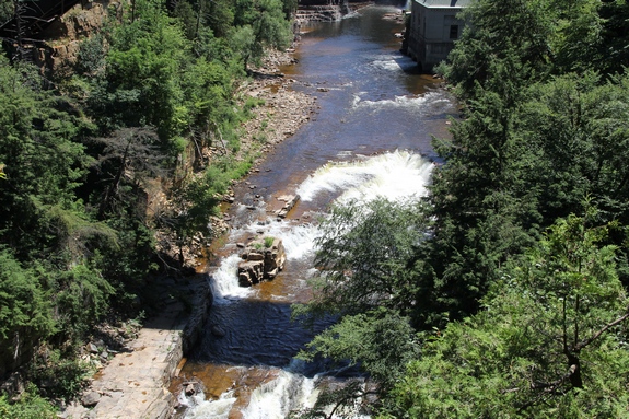
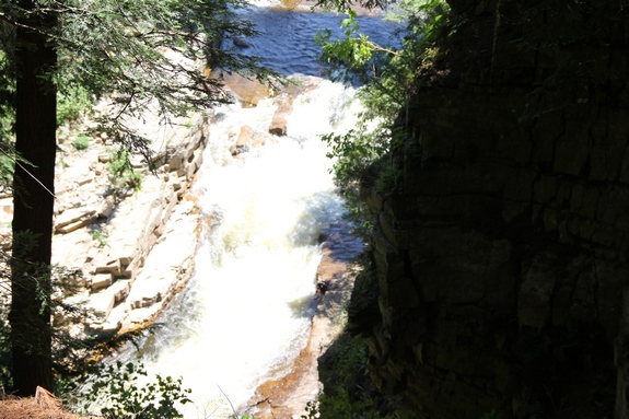
The trail map available at the welcome center notes seven (7)
waterfalls, only two (2) of them named, Rainbow and Horseshoe.
A large table relief map on display there also names Lower Horseshoe
Falls. We asked a clerk at the registration desk which one
this was on the trail map and she didn't seem to know it existed.
She asked a second clerk who likewise was clueless. Neither
of them seemed to know how many falls were at the site or where
they were.
We were only interested in the waterfalls and none of the other
attractions here. Since you can see Rainbow, Horseshoe and
Lower Horseshow from the Route 9 bridge, paying the fee will only
moderately enhance your views. The other four falls are not
marked on the trail and we didn't view them even from the trail.
In addition, since the staff couldn't answer some pretty basic questions,
we were left wondering about the effectiveness of their training
program.
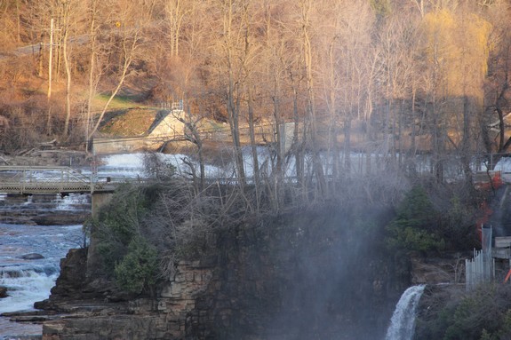
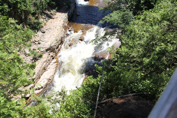
Our original pictures of Rainbow Falls, the biggest waterfall
attraction there had water coming from the hydro facility but not
over the falls themselves. We called the facility to inquire
about this a couple of months after our visit and it was explained
that there is a dam upstream operated by the New York State Gas
and Electric Company. They basically control the river.
Since we had just left Alice Falls
where there was a significant amount of water flowing over it, we
can only assume that they were diverting water to the hydro plant
for production. Given the reduced flow due to summer conditions,
there apparently wasn't enough water to support both the hydro production
and the waterfall! We did return the spring after our first
visit and got pictures from the bridge of water coming over Rainbow
Falls.
Our timing, both relative to the river level tour and the lack
of water at Rainbow Falls, caused us to leave this facility quite
disappointed. If you go there to see waterfalls, time it better
than we did! If you want to see the falls from ground level,
pay the $26. If you don't, simply view them from the bridge.
On a side note, Scott E. Brown, in his "New York Waterfalls,
A Guide for Hikers & Photographers" makes the claim that
the area we have identified as Rainbow Falls is actually Main Falls
and Rainbow is is the small ribbon falls on its right as you view
it from the bridge. We originally thought that these two drops
came from opposite sides of an island, but our local sources there
have now clarified that Rainbow Falls is the main waterfall on the
left as you view it from the bridge (river right). The other
side isn't a waterfall at all. It is actually the bypass from
the racks at the hydro-plant. A penstock feeds this side.
The West Branch of the Ausable River merges with the east branch
a few miles uptream from here in Au Sable Forks. The combined
Ausable River empties into Lake Champlain in the town of Peru.
Last update: April 29, 2017
|